Love and Loss in the Jemez

We’re lucky in that it appears Los Alamos Lab has dodged the bullet with respect to the Las Conchas Fire, but I do want to say something about 100,000 acres of some of the most beautiful land in New Mexico burning up in the Jemez Mountains. I know it fairly well.

Back in the early 1980’s I would take my kids out on a full moon night in the winter after it snowed on Highway 4 near the Valle Grande and pull them on an upside down car hood chained to my pickup (not recommended, but they loved it). I use to rock climb a lot at the Las Conchas Canyon on the east fork of the Jemez River (near where the fire broke out), and down at the southern end of the fire at Cochiti Mesa and Eagle Canyon (the erosion in Eagle Canyon after the 1996 Dome Fire was shocking, a harbinger of what is to come with this fire). I remember taking my kids to the beautiful Santa Clara Canyon to the north, which the fire is now devastating (my heartfelt condolences to the Pueblo). My parents took photos of me and my two brothers when we were small in the late 1950’s sitting in a Bandelier National Monument “cavate” (a hole in the canyon volcanic tuff further carved out by the Anasazi to live in), posing as the three little monkeys who hear no evil, see no evil, speak no evil.

As an adult I’ve been back country many times in Bandelier (now half burned), where on a map it looks like you walk say 5 miles but it will actually be eight by the time you climb up and down canyons. I know of a ponderosa pine in the Jemez where a buddy bigger than me (and I’m six feet) and I could not touch our fingers together while hugging its girth. I’m a tree hugger, but I also had chain saw thinning contracts all over the Jemez, including one on the south rim of the Frijoles Canyon above Bandelier (where thinning is sorely needed). I would occasionally run across unexcavated Anasazi pueblos and walls.

I’ve seen acres of trees in the Jemez covered with monarch butterflies during their migration to Mexico.

All this burned area is beautiful, beautiful country – beautiful forests, hoodoo rocks, clear streams, elk, bear, deer, eagles, hawks, peregrine falcons, ponderosa, pinon, alligator juniper in the south, blue spruce up high, New Mexico turquoise skies, deep snows in winter (in a good year) and hot springs.  These beautiful Jemez Mountains (not really peaks, but the more you know this land the more it grows on you). Are typically wetter than most of New Mexico, but this year so dry, and burning.

I pray that the trees, animals and the rains come back. But we humans must do our part, in the near term taking preventative measures against what could be devastating erosion now that the trees and grasses are gone. We need better forest management practices that allow fire to periodically sweep the forests (ponderosa pine evolved to adapt to and benefit from these low intensity fires), instead of suppressing them to the point where catastrophic crown fires break out. Longer term we need to begin to grapple effectively with global climate change, otherwise we may never get our Jemez forests back.

And we should comprehensively clean up Los Alamos Lab, because while it dodged the bullet this time, it may not the next time.

Beautiful, beautiful Jemez land, much of it gone – I love it and now I’m deeply missing it.
Jay Coghlan, Executive Director of Nuclear Watch New Mexico


Still Time to Comment on LANL’s Burning Desire for Expanded Weapons Production

Ironically today (June 28) is the deadline for public comment under the National Environmental Policy Act (NEPA) for concerned citizens to comment on a proposed ~$5 billion facility at the Los Alamos Lab ponderously called the Chemistry and Metallurgy Research Replacement Project- Nuclear Facility. In short, it is a huge new plutonium facility that will provide materials characterization and analytical chemistry in direct support of production of the atomic cores or “triggers” of nuclear weapons, commonly called the plutonium pits. The Nuclear Facility will be the keystone to an expanded complex at LANL’s Technical Area-55 that will quadruple production capacity from 20 to 80 pits per year.

I say ironically because of the fire that is now threatening the Lab. We need to begin questioning whether expanded nuclear weapons production at Los Alamos is feasible in a possibly long-term drought and climate warming punctuated with catastrophic forest fires. More broadly, as we face increasing budget and resource constraints, we need to decide whether our money and water go into expanded nuclear weapons production, or do they go into repairing schools and infrastructure for the common good of society?


The Risk to Waste Stored at Area G

We pride ourselves here at Nuclear Watch New Mexico on trying to stick to the facts as we best we know them and not being alarmist. That said, the Las Conchas Fire that has now crossed the Los Alamos National Laboratory’s (LANL’s) southwestern boundary is a real threat. For starters is the mind-blowing fact that in just 30 hours this fire has grown bigger than the notorious 2000 Cerro Grande Fire which burned ~48,000 acres (~5,000 acres within Lab boundaries), and traveled in a beeline 12 miles to get to the Lab. With forecasted days of strong winds and gusts and high temperatures it’s hard to say where this fire might go and what it might do. Pray for rain.

We are not so concerned about the hardened facilities at the Lab constructed of concrete and cleared of combustible materials (i.e., trees and brush) around their perimeters. We doubt that there would be any breech to their containment that would let contaminants escape (with one caveat below). But we do have concerns. One is the fact that over 6 decades the Lab has blown up a lot of uranium and depleted uranium in dynamic high explosives experiments in the general area in front of the fire. We don’t know to what extent the shrapnel or debris has been cleaned up and could possibly be aerosolized.

Another concern, given both the velocity and ferocity of the Las Conchas Fire, is whether any Lab facilities loose their power and back up generators failed to work for whatever reason. In that case containment systems could fail with unknown safety implications.

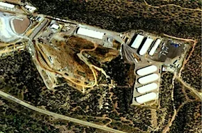
LANL TA-54 Material Disposal Area G
Domes at LANL's TA-54 Material Disposal Area G

But our biggest concern is whether the fire could reach the fabric buildings (essentially very large tents) at Technical Area-54’s Area G that store some 20,000 barrels of plutonium-contaminated wastes from nuclear weapons research and production. We recommend that the public use satellite-based fire detection data and fire intelligence information published by the US Forest Service to monitor the situation (see related post for instructions on how use it). From that we can “see” that the leading edge of the fire is a little more than three miles from Area G.

The good news is that the fire should slow down if and when it heads toward Area G because it will have to leave the mostly ponderosa forest into pinon and juniper country (which doesn’t crown fire like ponderosa). Also, the Lab has cleared trees and vegetation around Area G, and the fire would have to jump some major canyons just to get there.

So here’s hoping the fire doesn’t get anywhere close to Area G. But watch out if it does. The public should be concerned and really pay close attention. It might be a good time to take a road trip somewhere away from being downwind. This is one fire that cannot be underestimated.


Scroll to top